Printable Version of Topic
Click here to view this topic in its original format
AO Forum :: > National Land Mass & History > Old Maps


Posted by: Vilita Dec 19 2011, 01:45 AM
This is one of the earliest AO Maps in existence (There are a handful of older ones that are a bit less organized and sensible). This map is from before the great war that led to the glassing of Tachbe, which was a crucial transition point that marked the beginning of AO as a Sporting Empire vs. a non-sporting one.

user posted image

The R.L. Date on this map is 05/2004


--------------------------------------
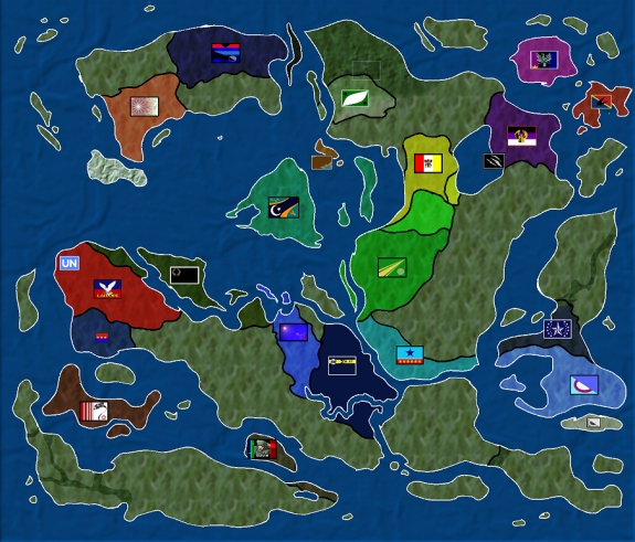
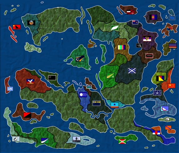
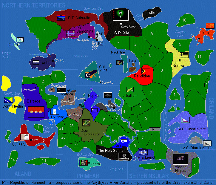
Historical Map Record:

https://atlantianoceania.com/uploads/post-39-1324277149.jpg
https://atlantianoceania.com/post-39-1324277585.jpg
http://www.3wideracing.com/3wide/sites/ao/maps/aomap.jpg
http://www.3wideracing.com/3wide/sites/ao/maps/aomapjan.jpg -- http://www.3wideracing.com/3wide/sites/ao/maps/aomapwater.jpg
http://www.3wideracing.com/3wide/sites/ao/maps/aomapfeb.jpg
http://www.3wideracing.com/3wide/sites/ao/maps/aomapmar.jpg
http://www.thirdgeek.com/maps/ao/2005/12/05/
http://www.thirdgeek.com/maps/ao/2005/12/06/ -- http://www.thirdgeek.com/maps/ao/land/2005/12/06/
http://www.thirdgeek.com/maps/ao/2005/12/10/ -- http://www.thirdgeek.com/maps/ao/large/2005/12/10/
http://www.thirdgeek.com/maps/ao/2005/12/13/ -- http://www.thirdgeek.com/maps/ao/large/2005/12/13/
http://www.thirdgeek.com/maps/ao/2006/01/03/ -- http://www.thirdgeek.com/maps/ao/large/2006/01/03/
http://www.thirdgeek.com/maps/ao/2006/01/06/ -- http://www.thirdgeek.com/maps/ao/large/2006/01/06/
http://www.thirdgeek.com/maps/ao/2006/01/21/ -- http://www.thirdgeek.com/maps/ao/large/2006/01/21/
http://www.thirdgeek.com/maps/ao/2006/01/28/ -- http://www.thirdgeek.com/maps/ao/large/2006/01/28/
http://www.thirdgeek.com/maps/ao/2006/02/03/ -- http://www.thirdgeek.com/maps/ao/large/2006/02/03/
http://www.thirdgeek.com/maps/ao/2006/02/11/ -- http://www.thirdgeek.com/maps/ao/large/2006/02/11/
http://www.thirdgeek.com/maps/ao/2006/03/10/ -- http://www.thirdgeek.com/maps/ao/large/2006/03/10/
http://www.thirdgeek.com/maps/ao/2006/03/15/ -- http://www.thirdgeek.com/maps/ao/large/2006/03/15/
http://www.thirdgeek.com/maps/ao/2006/04/01/ -- http://www.thirdgeek.com/maps/ao/large/2006/04/01/
http://www.thirdgeek.com/maps/ao/2006/05/01/ -- http://www.thirdgeek.com/maps/ao/large/2006/05/01/
http://www.thirdgeek.com/maps/ao/2006/06/17/ -- http://www.thirdgeek.com/maps/ao/large/2006/06/17/
http://www.thirdgeek.com/maps/ao/2006/07/10/ -- http://www.thirdgeek.com/maps/ao/large/2006/07/10/
http://www.thirdgeek.com/maps/ao/2006/07/29/ -- http://www.thirdgeek.com/maps/ao/large/2006/07/29/
http://www.thirdgeek.com/maps/ao/2006/12/09/
http://www.thirdgeek.com/maps/ao/2007/04/22/
http://www.thirdgeek.com/maps/ao/2007/05/19/
http://www.thirdgeek.com/maps/ao/2007/06/18/
http://www.thirdgeek.com/maps/ao/2007/12/04/
http://www.thirdgeek.com/maps/ao/2008/03/06/
http://www.thirdgeek.com/maps/ao/2008/11/09/
http://www.thirdgeek.com/maps/ao/2009/03/31/
http://www.thirdgeek.com/maps/ao/2010/01/17/ -- http://www.thirdgeek.com/maps/ao/cities/2010/01/17/
http://www.thirdgeek.com/maps/ao/2011/12/07/ -- http://www.thirdgeek.com/maps/ao/cities/2011/12/07/
http://i989.photobucket.com/albums/af14/ASMVandDandS/52312-1.png
http://i989.photobucket.com/albums/af14/ASMVandDandS/0604-12.png
http://i989.photobucket.com/albums/af14/ASMVandDandS/postwightmap.png
http://2015-02-10.atlantianoceania.com/
http://www.3wideracing.com/3wide/sites/ao/maps/12-11-20.png
http://www.3wideracing.com/3wide/sites/ao/maps/12-12-12.png
http://www.3wideracing.com/3wide/sites/ao/maps/13-01-16.png
http://www.3wideracing.com/3wide/sites/ao/maps/13-02-10.png
http://www.3wideracing.com/3wide/sites/ao/maps/13-02-27.png
http://www.3wideracing.com/3wide/sites/ao/maps/13-04-14.pnghttps://atlantianoceania.com/files/13-04-14-Timezones.jpg
http://www.3wideracing.com/3wide/sites/ao/maps/13-05-17.png
http://www.3wideracing.com/3wide/sites/ao/maps/2013-06-AOCitiesMap.png
http://www.3wideracing.com/3wide/sites/ao/maps/13-07-05.png
http://www.3wideracing.com/3wide/sites/ao/maps/13-10-15.png
http://www.3wideracing.com/3wide/sites/ao/maps/13-11-07.png
http://www.3wideracing.com/3wide/sites/ao/maps/14-01-20.png
http://www.3wideracing.com/3wide/sites/ao/maps/2014-04-21.png
http://www.3wideracing.com/3wide/sites/ao/maps/2014-07-02.png
http://www.3wideracing.com/3wide/sites/ao/maps/2015-02-10.png

Posted by: Vilita Dec 19 2011, 01:51 AM
Here is a map evolution from 3 Months after the map posted above. The currently accepted geography of AO becomes more prevalent, Tachbe has been glassed and future sporting superpowers Starblaydia, Sarzonia and Krytenia arrive as n00bs, as well as Lamoni, NEWI Cefn Druids and Pedriana.

user posted image

Posted by: Andossa Se Mitrin Vega Dec 19 2011, 01:55 AM
Those are awesome. it is really cool to see the progression from the first inw to where we are now.

Posted by: The Bear Islands Dec 19 2011, 07:09 AM
Somebody really had a nation called 'Abattoir'?!? I dread to think what living there must have been like...

happy.gif

Posted by: Falcania Dec 19 2011, 09:01 AM
Good god, this makes me feel OLD. When I set up shop, Xile, Abattoir and Crystilakere/Diamindokere were still knocking about.

Obviously that's before I got my mittens on Diamindokere.

And I remember some of the old guard. Nedalia, Khazaron, Bazalonia, even Lamoni, before we fell out over egregious miscalculations towards his tiny economy.

Posted by: Vilita Dec 19 2011, 07:35 PM
Here is the first map ever that had Falcania on it.

I assume its from about March 2005.

user posted image

Posted by: The Bear Islands Dec 20 2011, 05:37 AM
Was the island labelled 'UN' meant as a claim that this region was hosting the NS-UN's headquarters?

Posted by: Nojika Dec 20 2011, 10:50 AM
Wow...

Like Falcania said, this certainly makes me feel old! I had forgotten about Nova Roma and Tachbe!

No, The Bear Isles, that island was a part of Lamoni who was our UN delegate at the time.

Posted by: Falcania Dec 20 2011, 01:18 PM
Also, nice to know my current military outpost is squatting in Lamoni's dirt.

Posted by: The Bear Islands Dec 21 2011, 07:02 AM
QUOTE (Nojika @ Dec 20 2011, 10:50 AM)
No, The Bear Isles, that island was a part of Lamoni who was our UN delegate at the time.

Thank you for the explanation.

Posted by: Vilita Dec 30 2011, 03:21 PM
Interesting to see how the Nomadic Peoples of Krytenia have walked around too tongue.gif

Posted by: Vilita Jan 8 2012, 11:20 PM
Other Old Maps From 2005 to Current:

http://thirdgeek.com/maps/aoarchive/aoarchive.php

Posted by: Legalese Jan 8 2012, 11:59 PM
QUOTE (Vilita @ Jan 9 2012, 12:20 AM)
Other Old Maps From 2005 to Current:

http://thirdgeek.com/maps/aoarchive/aoarchive.php

Valanora may never talk to me again for saying this, but I kinda enjoy the map from 12/9/2006, even though it's also the first one I was removed from. biggrin.gif

Posted by: Vilita Jan 9 2012, 12:11 AM
QUOTE (Legalese @ Jan 9 2012, 12:59 AM)
QUOTE (Vilita @ Jan 9 2012, 12:20 AM)
Other Old Maps From 2005 to Current:

http://thirdgeek.com/maps/aoarchive/aoarchive.php

Valanora may never talk to me again for saying this, but I kinda enjoy the map from 12/9/2006, even though it's also the first one I was removed from. biggrin.gif

It was also very nearly full at that stage; )

Posted by: Valanora Jan 9 2012, 01:36 AM
I hate both of you.

Posted by: Vilita Jan 9 2012, 01:38 AM
QUOTE (Valanora @ Jan 9 2012, 02:36 AM)
I hate both of you.

Don't shoot the messenger

Posted by: Pacitalia Jan 10 2012, 03:38 PM
Wow, it's hard to believe I have been in this region for just over 6 years... but I guess that's what happens when you play this game for almost 10. wink.gif

Posted by: Vilita Jan 10 2012, 09:44 PM
QUOTE (Pacitalia @ Jan 10 2012, 04:38 PM)
Wow, it's hard to believe I have been in this region for just over 6 years... but I guess that's what happens when you play this game for almost 10. wink.gif

I wonder, what region I was in before AO.

I wonder if theres ever a way to find out

Posted by: Vilita Jul 15 2012, 11:30 AM
AO Waterways Map, pre some of the recent landmass changes.

http://files.atlantianoceania.com/maps/aomapwater.jpg

Posted by: Starblaydia Jul 18 2012, 04:16 AM
QUOTE (Legalese @ Jan 9 2012, 05:59 AM)
QUOTE (Vilita @ Jan 9 2012, 12:20 AM)
Other Old Maps From 2005 to Current:

http://thirdgeek.com/maps/aoarchive/aoarchive.php

Valanora may never talk to me again for saying this, but I kinda enjoy the map from 12/9/2006, even though it's also the first one I was removed from. biggrin.gif

That was probably our http://www.thirdgeek.com/maps/ao/2006/12/09/ in terms of "look, we're like a real place"

In my mind, Legalese slots into #2, Falc has expanded into #3 and Cockbill Street is still #4.

Love it.

Posted by: Falcania Jul 18 2012, 04:29 AM
I remember that map. Halcyon days. You can see why I really wanted Diamindokere's soil, can't you? It was just a Falcania-shaped hole.

Posted by: Wight Jul 21 2012, 11:09 AM
Wow, I love this thread. I see I have inherited the broken version of Köseli Cumhurîyetler. I plan to continue 'The Great Remove' in AOCAF, and I think a little bit of archeology might turn up remnants of KCU. Does anyone have anything I can go on? Anyone remember something interesting about the user, or if they are still around in a different form, point me to their new nation?

EDIT: OK, engaged research head and found a usable wiki article plus a few WC-48 RPs so I have something to work with. But if the user is still around in another form and someone can identify them, it would be good to make contact.

Posted by: Vilita Jul 21 2012, 11:50 AM
http://www.atlantianoceania.com/uploads/post-39-1324277149.jpg
http://www.atlantianoceania.com/uploads/post-39-1324277585.jpg
http://files.atlantianoceania.com/maps/aomap.jpg
http://files.atlantianoceania.com/maps/aomapjan.jpg -- http://files.atlantianoceania.com/maps/aomapwater.jpg
http://files.atlantianoceania.com/maps/aomapfeb.jpg
http://files.atlantianoceania.com/maps/aomapmar.jpg
http://www.thirdgeek.com/maps/ao/2005/12/05/
http://www.thirdgeek.com/maps/ao/2005/12/06/ -- http://www.thirdgeek.com/maps/ao/land/2005/12/06/
http://www.thirdgeek.com/maps/ao/2005/12/10/ -- http://www.thirdgeek.com/maps/ao/large/2005/12/10/
http://www.thirdgeek.com/maps/ao/2005/12/13/ -- http://www.thirdgeek.com/maps/ao/large/2005/12/13/
http://www.thirdgeek.com/maps/ao/2006/01/03/ -- http://www.thirdgeek.com/maps/ao/large/2006/01/03/
http://www.thirdgeek.com/maps/ao/2006/01/06/ -- http://www.thirdgeek.com/maps/ao/large/2006/01/06/
http://www.thirdgeek.com/maps/ao/2006/01/21/ -- http://www.thirdgeek.com/maps/ao/large/2006/01/21/
http://www.thirdgeek.com/maps/ao/2006/01/28/ -- http://www.thirdgeek.com/maps/ao/large/2006/01/28/
http://www.thirdgeek.com/maps/ao/2006/02/03/ -- http://www.thirdgeek.com/maps/ao/large/2006/02/03/
http://www.thirdgeek.com/maps/ao/2006/02/11/ -- http://www.thirdgeek.com/maps/ao/large/2006/02/11/
http://www.thirdgeek.com/maps/ao/2006/03/10/ -- http://www.thirdgeek.com/maps/ao/large/2006/03/10/
http://www.thirdgeek.com/maps/ao/2006/03/15/ -- http://www.thirdgeek.com/maps/ao/large/2006/03/15/
http://www.thirdgeek.com/maps/ao/2006/04/01/ -- http://www.thirdgeek.com/maps/ao/large/2006/04/01/
http://www.thirdgeek.com/maps/ao/2006/05/01/ -- http://www.thirdgeek.com/maps/ao/large/2006/05/01/
http://www.thirdgeek.com/maps/ao/2006/06/17/ -- http://www.thirdgeek.com/maps/ao/large/2006/06/17/
http://www.thirdgeek.com/maps/ao/2006/07/10/ -- http://www.thirdgeek.com/maps/ao/large/2006/07/10/
http://www.thirdgeek.com/maps/ao/2006/07/29/ -- http://www.thirdgeek.com/maps/ao/large/2006/07/29/
http://www.thirdgeek.com/maps/ao/2006/12/09/
http://www.thirdgeek.com/maps/ao/2007/04/22/
http://www.thirdgeek.com/maps/ao/2007/05/19/
http://www.thirdgeek.com/maps/ao/2007/06/18/
http://www.thirdgeek.com/maps/ao/2007/12/04/
http://www.thirdgeek.com/maps/ao/2008/03/06/
http://www.thirdgeek.com/maps/ao/2008/11/09/
http://www.thirdgeek.com/maps/ao/2009/03/31/
http://www.thirdgeek.com/maps/ao/2010/01/17/ -- http://www.thirdgeek.com/maps/ao/cities/2010/01/17/
http://www.thirdgeek.com/maps/ao/2011/12/07/ -- http://www.thirdgeek.com/maps/ao/cities/2011/12/07/
http://i989.photobucket.com/albums/af14/ASMVandDandS/52312-1.png
http://i989.photobucket.com/albums/af14/ASMVandDandS/0604-12.png
http://i989.photobucket.com/albums/af14/ASMVandDandS/postwightmap.png
http://files.atlantianoceania.com/maps/12-10-21.png
http://files.atlantianoceania.com/maps/12-11-20.png
http://files.atlantianoceania.com/maps/12-12-12.png
http://files.atlantianoceania.com/maps/13-01-16.png
http://files.atlantianoceania.com/maps/13-02-10.png
http://files.atlantianoceania.com/maps/13-02-27.png
http://files.atlantianoceania.com/maps/13-04-14.pnghttp://files.atlantianoceania.com/maps/13-04-14-Timezones.jpg
http://files.atlantianoceania.com/maps/13-05-17.png
http://files.atlantianoceania.com/maps/2013-06-AOCitiesMap.png"
http://files.atlantianoceania.com/maps/13-07-05.png
http://files.atlantianoceania.com/maps/13-10-15.png
http://files.atlantianoceania.com/maps/13-11-07.png
http://files.atlantianoceania.com/maps/14-01-20.png
http://files.atlantianoceania.com/maps/2014-04-21.png
http://files.atlantianoceania.com/maps/2014-07-02.png
http://files.atlantianoceania.com/maps/2015-02-10.png

Powered by Invision Power Board (http://www.invisionboard.com)
© Invision Power Services (http://www.invisionpower.com)